Report to/Rapport au :
Comité de l'urbanisme et de l'environnement
and Council / et au Conseil
21
July 2006 / le 21 juillet 2006
Submitted by/Soumis par : John
L. Moser, Acting Deputy City Manager/Directeur municipal adjoint par intérim,
Planning
and Growth Management / Urbanisme et Gestion de la croissance
Contact
Person/Personne ressource : Michael Wildman, Acting Manager/Gestionnaire
interimaire, Infrastructure Approvals/Approbation des demandes d'infrastructure
(613) 580-2424, 27811 Mike.Wildman@ottawa.ca
|
SUBJECT: |
mER bLEUE rOAD AND
TENTH LINE ROAD ENVIRONMENTAL ASSESSMENTS |
|
|
|
|
OBJET : |
ÉVALUATIONS
ENVIRONNEMENTALES DU CHEMIN MER-BLEUE ET DU CHEMIN TENTH-LINE |
REPORT RECOMMENDATION
That
Transportation Committee recommend Council:
1.
Receive the results of the Mer Bleue Road Environmental Assessment,
as shown in Document 2 of this report, that were developed in accordance with
the requirements of the Ontario
Environmental Assessment Act and Municipal Class Environmental Assessment.
1.
2.
Request staff prepare the Environmental Study Report for the Mer
Bleue Road Environmental Assessment for the 30-day public review, in accordance
with the Ontario Environmental Assessment
Act.
3.
Receive the results of the Tenth Line Road Environmental Assessment,
as shown in Document 6 of this report, that were developed in accordance with
the requirements of the Ontario
Environmental Assessment Act and Municipal Class Environmental Assessment.
4.
Request staff prepare the Environmental Study Report for the Tenth
Line Road Environmental Assessment for the 30-day public review, in accordance
with the Ontario Environmental Assessment
Act.
5.
Request staff undertake necessary property acquisition for the
construction of Mer Bleue Road and Tenth Line Road. Funding for the first stages of these tasks
are approved through capital accounts 903211 Mer Bleue Road and 903219 Tenth
Line Road, as approved in the 2005 Capital Budget.
RECOMMANDATION DU RAPPORT
Que le Comité des transports
recommande au Conseil :
1. de recevoir les résultats de l'évaluation environnementale du chemin Mer-Bleue, constituant le document 2 ci-annexé, qui ont été obtenus sous le régime de la Loi sur les évaluations environnementales de l'Ontario et conformément aux exigences de l'Évaluation environnementale municipale de portée générale;
2. de demander au personnel de rédiger le rapport d'étude relative à l'évaluation environnementale du chemin Mer-Bleue en vue de l'examen public de 30 jours prescrit par la Loi sur les évaluations environnementales de l'Ontario;
3. de recevoir les résultats de l'évaluation environnementale du chemin Tenth-Line, constituant le document 6 ci-annexé, qui ont été obtenus sous le régime de la Loi sur les évaluations environnementales de l'Ontario et conformément aux exigences de l'Évaluation environnementale municipale de portée générale;
4. de demander au personnel de rédiger le rapport d'étude relative à l'évaluation environnementale du chemin Tenth-Line en vue de l'examen public de 30 jours prescrit par la Loi sur les évaluations environnementales de l'Ontario;
5. de
demander au personnel d'entreprendre les acquisitions de terrains nécessaires à
la construction des chemins Mer-Bleue et Tenth-Line; le financement des
premières étapes de ces travaux proviendra des comptes d'immobilisation 903211
(chemin Mer-Bleue) et 903219 (chemin Tenth-Line), approuvés dans le budget des
immobilisations de 2005.
EXECUTIVE SUMMARY
Assumptions
and Analysis:
Ottawa’s East Urban Community is anticipated to continue growing to a population of 131,000 people and 45,000 jobs by 2021. In recent years, significant residential and commercial development has occurred along the Innes Road corridor. New infrastructure and roadways will be required to accommodate this growth. Two roadways identified for improvements are Mer Bleue Road and Tenth Line Road.
The City of Ottawa initiated the Mer Bleue Road Environmental Assessment (EA) at the beginning of 2006 to obtain environmental approvals to proceed with constructing a portion of the roadway, between Innes Road and the future Vanguard Drive extension. Similarly, the Tenth Line Road EA began at the same time in order to meet 2006/07 construction deadlines for a trunk sanitary sewer, as well as a roadway section between Innes Road and Lakepointe Drive.
The result of the Mer Bleue Road EA is a new development plan for the roadway. At the north end, the roadway will be widened to the west, where the City currently owns the majority of the property. Travelling south of Renaud Road, the plan calls for a new road corridor to extend west of the Notre-Dame-des-Champs community and intersect with Navan Road, at a new intersection. The improvements for this roadway will include pedestrian sidewalks and bicycle lanes. This plan was developed through a detailed evaluation exercise. Moving the alignment outside of Notre-Dame-des-Champs avoids any negative social impacts to the community.
The Tenth Line Road EA concluded that widening about the centreline to a four-lane urban, divided arterial, which includes exclusive bicycle lanes and pedestrian facilities is the appropriate development plan for the roadway. This plan will be implemented throughout the length of Tenth Line Road, from Innes Road to the Urban Boundary.
Financial
Implications:
The funding for the Mer Bleue Road and Tenth Line Road EAs was approved in the 2005 Capital Budget in accounts 903211 and 903219 respectively.
Public
Consultation/Input:
Both EA studies were undertaken as Class C Municipal EAs. The details for each project are listed below:
Mer Bleue EA:
Public Open House #1 - February 15/21, 2006;
Public Open House #2 - April 5, 2006;
Public Open House #3 - May 23, 2006;
Agency Consultation Group (ACG) Meetings - four held throughout the course of the study;
Public Consultation Group (PCG) Meetings - two held throughout the course of the study;
Transportation Committee – August 16, 2006.
Tenth Line EA:
Public Open House #1 - February 15/21, 2006;
Public Open House #2 - April 11, 2006;
Public Open House #3 - May 30, 2006;
ACG Meetings – three held throughout the course of the study;
PCG Meetings – three held throughout the course of the study;
Transportation Committee - August 16, 2006.
In addition to these events, web pages for both studies were developed and hosted on the City of Ottawa's site, within the Public Consultation link.
RÉSUMÉ
Hypothèses de travail et analyse :
Il est prévu que la Communauté
urbaine Est d'Ottawa continuera de croître et qu'elle comptera 131 000
habitants et 45 000 emplois d'ici à 2021. Ces dernières années, il y a eu
beaucoup de développement résidentiel et commercial le long du corridor du
chemin Innes. Une telle croissance nécessitera l'aménagement de nouvelles
infrastructures et de nouvelles routes. Des améliorations sont prévues
notamment pour les chemins Mer Bleue et Tenth Line.
Au début de 2006, la Ville d'Ottawa a amorcé
l'évaluation environnementale (ÉE) du chemin Mer Bleue dans le but d'obtenir
les autorisations nécessaires en matière d'environnement pour procéder à la
construction d'un tronçon de cette route entre le chemin Innes et la promenade
Vanguard, qui sera éventuellement prolongé. Parallèlement, on a entrepris
l'évaluation environnementale du chemin Tenth Line afin de respecter les
échéances fixées en 2006-2007 pour l'aménagement d'un égout collecteur et d'un
raccordement routier entre le chemin Innes et la promenade Lakepointe.
L'évaluation environnementale du chemin Mer
Bleue a débouché sur un nouveau plan d'aménagement pour cette artère. Dans la
partie nord, la chaussée sera élargie du côté ouest, où la Ville possède la
plupart des terrains. Au sud du chemin Renaud, le plan prévoit l'aménagement,
en direction ouest à partir de la communauté Notre-Dame-des-Champs, d'un
nouveau corridor routier qui croisera le chemin Navan. Cette voie publique sera
dotée notamment de trottoirs et de voies cyclables. Ce plan est le fruit d'un
travail d'évaluation soigné. En modifiant le tracé de la route pour qu'elle
contourne Notre-Dame-des-Champs, il n'y a pas de conséquences sociales
indésirables pour cette collectivité.
Selon l'évaluation environnementale du chemin
Tenth Line, le plan d'aménagement qui convient pour cette artère comprend
l'élargissement de la chaussée à quatre voies avec terre-plein au centre, des
voies pour les cyclistes et des installations pour les piétons. Un tel plan
viserait le chemin Tenth Line d'un bout à l'autre, du chemin Innes jusqu'à la
limite du territoire urbain.
Financement requis :
Le financement des évaluations
environnementales visant les chemins Mer Bleue et Tenth Line a été approuvé
dans le Budget d'immobilisations de 2005, aux postes 903211 et 903219
respectivement.
Consultation/participation du
public :
Les deux études sont menées
conformément aux dispositions de l'annexe C pour une évaluation
environnementale municipale de portée générale. Les détails concernant chaque
projet sont énumérés ci-dessous :
Étude ÉE Mer Bleue :
Réunion portes ouvertes no 1 - 15/21
février 2006;
Réunion portes ouvertes no 2 - 5
avril 2006;
Réunion portes ouvertes no 3 - 23
mai 2006;
Réunions du Groupe de consultation des
organismes (GCO) - tenue de quatre réunions au cours de l'étude;
Réunions du Groupe de consultation publique
(GCP) - tenue de deux réunions au cours de l'étude;
Comité des transports – 16 août 2006.
Étude ÉE Tenth Line :
Réunion portes ouvertes no 1 - 15/21
février 2006;
Réunion portes ouvertes no 2 - 11 avril 2006;
Réunion portes ouvertes no 3 - 30
mai 2006;
Réunions GCO – tenue de trois réunions au cours
de l'étude;
Réunions GCP – tenue de trois réunions au cours
de l'étude;
Comité des transports - 16 août 2006.
Outre ces activités, des pages web ont été
élaborées pour les deux études et affichées au site de la Ville d'Ottawa sous
le lien Consultations publiques.
BACKGROUND
This staff report presents the results of two different EA studies, for both Mer Bleue Road and Tenth Line Road. While they are distinct projects, they are being presented together in this staff report as they are both located in the same vicinity in the east end of the City, have similar need requirements and construction schedules and, are both funded by development charges. As well, presenting them together allows any member of the public to address Transportation Committee about both projects at the same time.
This staff report is organized in the following manner:
- Section A - Mer Bleue Road;
- Section B – Tenth Line Road.
Attached Documents to this report are the study area graphics, illustrations of the Recommended Plan, detailed summaries of the public consultation exercise and evaluation process for each study.
Planning Context for Both Studies
Ottawa’s East Urban Community is anticipated to continue growing to a population of 131,000 people and 45,000 jobs by 2021. In recent years, significant residential and commercial development has located along the Innes Road corridor. As well, several on-going s south of Innes Road, abutting both the Mer Bleue Road and Tenth Line Road corridors are in the planning stages. These communities include:
- Eden Park;
- Mer Bleue – Neighbourhood 5;
- East Urban Community – Phase 1;
- East Urban Community – Phase 2;
- Avalon Subdivision – Neighbourhood 4.
New infrastructure and roadways will be required to accommodate this growth. Two roadways identified for improvements are Mer Bleue Road and Tenth Line Road.
The City initiated the Mer Bleue EA at the beginning of 2006 in order to obtain environmental approval to proceed with the first phase of the roadway construction, between Innes Road and future Vanguard Drive. This section of roadway requires widening in 2006/07 to accommodate the growth demands in the Orléans Industrial Park. Similarly, the Tenth Line Road EA was conducted over the same time period in order to meet the 2006/07 construction deadlines for its first phase between Innes Road and Lakepointe Drive.
Following the Municipal Class EA process and the advice of the Ministry of the Environment, these studies determined and recommend the future alignment and configuration for Mer Bleue Road between Innes Road and Navan Road and Tenth Line Road between Innes Road and the Urban Boundary.
DISCUSSION
SECTION A – MER BLEUE ROAD ENVIRONMENTAL ASSESSMENT
The requirement for improvements to Mer Bleue Road can be described in two time horizons. In the near term, the northern section of this roadway needs to be widened to accommodate the traffic demands of the adjacent development. Approximately 45,000 square metres of retail space will be located on the southwest corner of Innes Road and Mer Bleue Road. The traffic impact study for the development revealed a growth in trips to/from this destination. The site will have several accesses to Mer Bleue Road. As such, opposing through and turning movements create the need for properly designed intersections and auxiliary lanes. The ultimate cross section will need to include four lanes. As stated in the BACKGROUND section, Mer Bleue Road, between Innes Road and the future Vanguard Drive is intended to be built in 2006/2007 to meet the pace of development.
In the longer term, there will be approximately 6,850 new dwelling units with a population of 18,400 and 575 new employment opportunities in Phases 1 and 2 of the East Urban Community, south of Innes Road. In addition, the Mer Bleue Community Design Plan (CDP), that was presented to Planning and Environment Committee in April of this year, predicts this area will have 8,000 residents occupying some 2,800 new dwelling units and 4,500 new jobs. A transportation review for the new development was completed in March of this year as a supporting document to the CDP. The study projected the future volumes for Mer Bleue Road south of future Vanguard Drive to Navan Road will require a widening to a four-lane facility. The timing for these improvements will be driven by the pace of development and have been identified in the City’s Development Charge By-law and Long Range Financial Plan.
Study Area Features
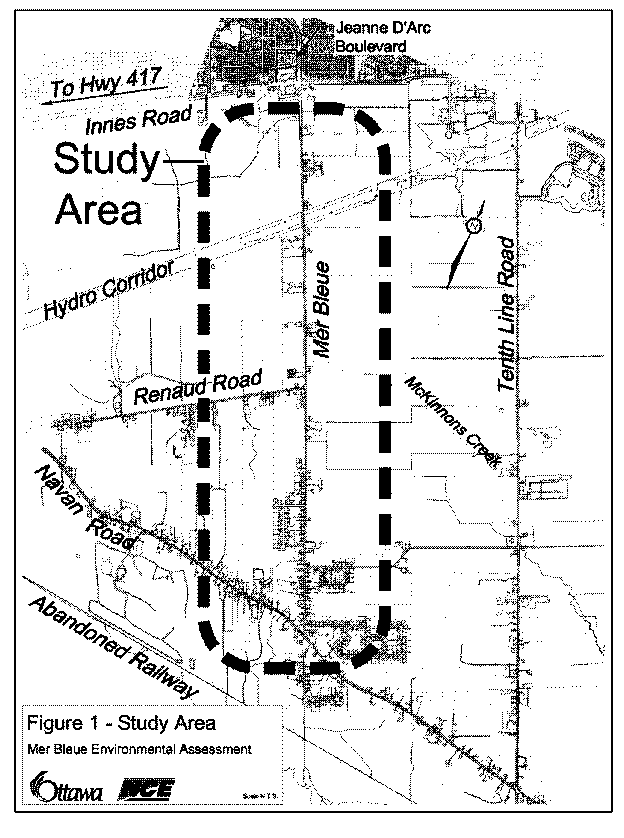
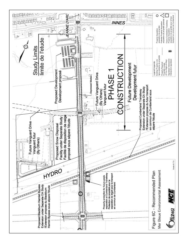
Mer Bleue Road is a two-lane roadway that runs southerly from Innes Road to Navan Road (see Document 1). At the north end, it is adjacent to a proposed commercial site, which is currently under development. The planned Cumberland Transitway (currently under study as part of the East-West Light Rail EA) runs parallel to the Hydro Corridor and will be protected for a future grade separation at Mer Bleue Road. This crossing of the Transitway at Mer Bleue Road is just north of the future intersection with the Blackburn Hamlet By-pass Extension. On the west side of the corridor, Council recently approved the CDP for the East Urban Community, Phase 1 in 2005. McKinnons Creek also traverses the road, running west to east.
Continuing south, rural lots/homes, farms and treed areas flank the roadway. Mer Bleue Road intersects with Renaud Road, where Renaud Road terminates at a tee intersection. Just south of Renaud Road, on the west side, a place of worship is planned, however to date no site plan has been submitted to the City. There also exists a woodlot that has natural environmental value as it is a groundwater recharge area for the Mer Bleue Bog. On the east side, south of Renaud Road, the land use is primarily farming with some wooded areas.
The south end of the study area is the village of Notre-Dame-des-Champs. A number of homes and businesses front onto Mer Bleue Road and the remainder of the community is located off local road connections such as Du Palais, Du Domaine and Wall Roads. Behind these dwellings, on the west side, is the wooded recharge area for the bog. Sabourin Creek and a recreational trail run through this area.
Alternative Planning Solutions
In accordance with the Environmental Assessment Act, as well as good planning principles, several planning and alignment alternatives were developed. They were analyzed in a hierarchical methodology to scope the higher level solutions that should be carried forward, then provide a detailed analysis of various alternative designs.
The planning level alternative solutions tested the assumption that a roadway is needed. The following is a list of these solutions and the rationale for carrying them forward or not:
- Do nothing – not carried forward as it does not address the mobility needs of the growing East Urban Community.
- Transit – recommended to be carried forward as part of the list of complementary solutions to address the future travel demand of the East Urban Community. Transit improvements will take the form of the facilities identified in the Transportation Master Plan, such as the Cumberland Transitway/East-West LRT, the East Transitway and local transit improvements and transit priority. All of these are technically recommended to be implemented in an effort to achieve the City’s modal split goals. However, transit alone will not satisfy the needs identified in the previous section.
- Transportation System Management and Transportation Demand Management – both of these measures can and will have an impact on the necessary capacity identified in the needs section. As with transit, these trip reducing strategies are recommended to be carried forward, however they do not satisfy the basic need for widening Mer Bleue Road as defined in the TMP.
- Mer Bleue Roadway Improvements – this alternative is recommended to be carried forward through a detailed evaluation methodology to define the future configuration of the roadway. This recommendation is based on this solution’s ability to address the future deficiencies associated with adjacent developments.
Analysis and Evaluation Process
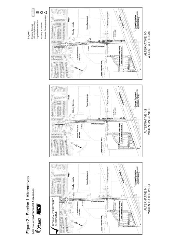
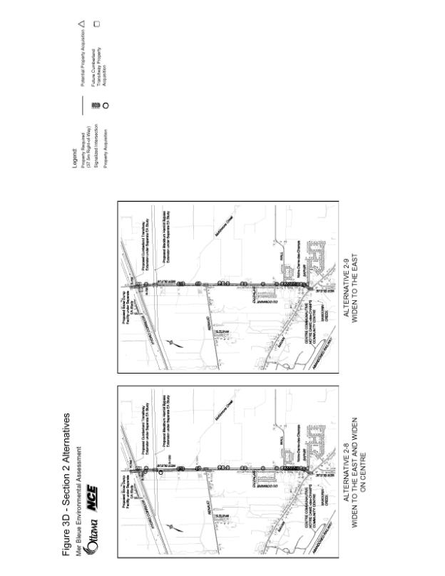
The project was divided into two sections for evaluation purposes. The two sections were:
- Section 1 - extends from Innes Road southerly to the Hydro Corridor. A total of three alternatives were developed and carried forward for a qualitative analysis for this section.
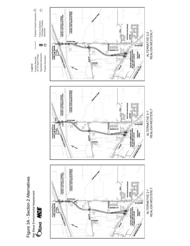
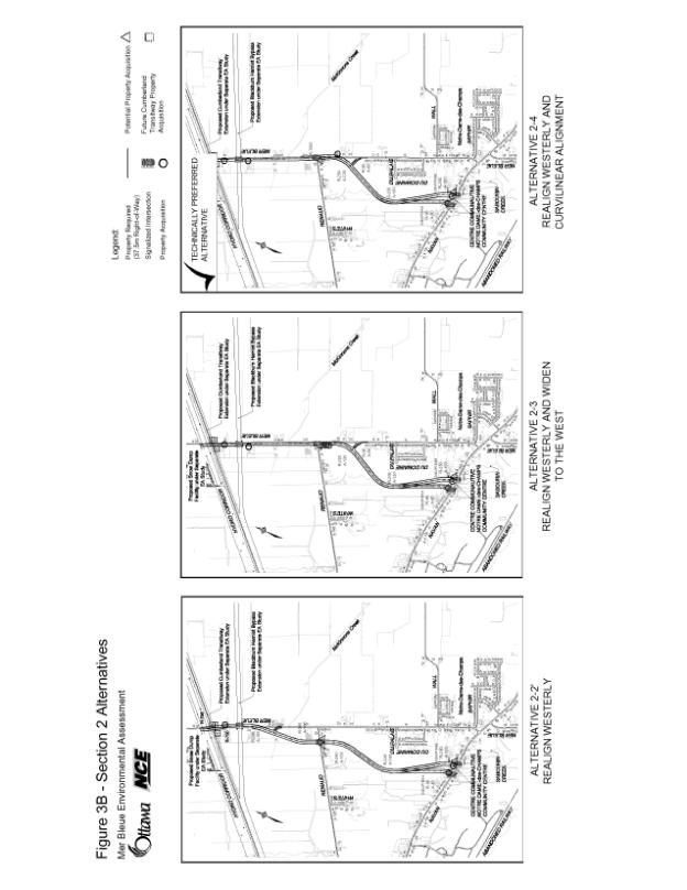
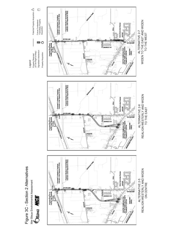
- Section 2 - extends from the Hydro Corridor southerly to Navan Road. A total of four alternative corridors were reviewed for this Section. The alternative corridors considered routes to the east and west of Notre-Dame-des-Champs as well as the existing alignment through the community. Routes to the east were not carried forward because of greater impacts to active farmland, increase spacing of arterial roadways and separation from planned development in the urban area. Corridors through and west of Notre-Dame-des-Champs were carried forward. Following the selection of the preferred corridors a quantitative assessment was undertaken for alignment alternatives.
Document 3 contains a detailed description of the analysis and evaluation process, including drawings of the different alternatives.
For Section 1 (Innes Road to Hydro Corridor), the alternative which widens Mer Bleue Road to the west was selected as the technically preferred alternative. This alternative has minimal property required on the west because much of the property has already been dedicated to the City and is currently vacant. The alternative has no impact on the existing residential homes on the east side of Mer Bleue Road. An unequal widening to the west is consistent with the Official Plan protection for Mer Bleue Road as this plan will ensure proper alignment with Jeanne d’Arc Boulevard to the north of Innes Road.
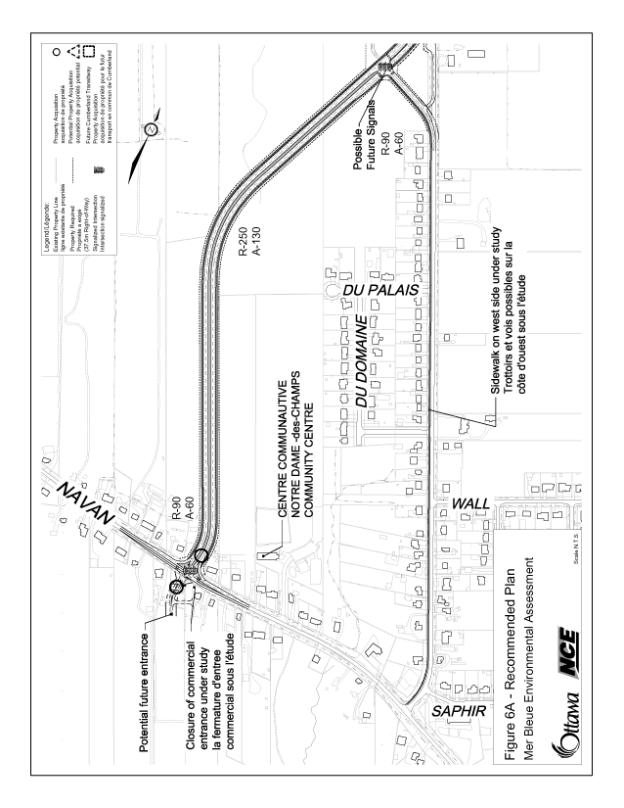
The technically preferred alternatives for Section 2 widens Mer Bleue Road to the west (Hydro Corridor to Renaud Road) and realigns to the west, in a new corridor (from Renaud Road to Navan Road) with a curvilinear alignment at Renaud Road avoiding impact to the existing Notre-Dame-des-Champs community. The current Mer Bleue Road will remain and serve the Notre-Dame-des-Champs Community as a collector road, with the larger volumes of traffic, including trucks, travelling on the new alignment. The existing Mer Bleue Road will continue to be a two‑lane roadway with the introduction of a sidewalk on the west side of the road from the new intersection southerly to Navan Road.
The recommended cross section is a 37.5 metre, four-lane divided roadway with bicycles lanes, sidewalks, median and landscaping. This is a typical cross section containing all elements specified in the City’s Arterial Roadway Design Guidelines.
These alternatives and cross section were assembled to create the overall technically preferred plan. This plan was reviewed and endorsed by the Agency and Public Consultation Groups.
Refinements
Based on comments received from the public following public open house #2, at which the technically preferred plan was presented, several refinements were made. The refinements included:
1. Section 1 - Recommendation to provide a dropped median for homeowner at 2107 Mer Bleue Road (School bus driver) for school bus access/egress. The dropped median will remain in place until the future Vanguard Drive is constructed or if the ownership changes at which time the median will be rebuilt as a raised median.
2. Section 2 - For the future site located south of Renaud Road, which is planned to be a place of worship, discussions with the land owners revealed that a site plan was prepared in the 1990s but not approved. They have not had the resources to proceed with development. The technically preferred plan includes a shift in the roadway alignment that minimized the impacts on this site and avoided the need to purchase two homes immediately to the north. Discussions with the homeowners at PCG meetings revealed that given their proximity to an arterial roadway, they would prefer to be purchased. As such, the EA is recommending that the homes be purchased and the residual land available be exchanged to the place of worship. This scenario is beneficial to the City as it removes the driveway entrances from the intersection and provides a safer alignment for the roadway, which will be there for decades to come.
These recommendations were presented to the public at open house #3 and are included in the final recommended plan developed through the EA process.
Recommended Plan
The Recommended Plan and Cross Section are illustrated in Document 2. The following is a summary of the Plan:
- Between Innes Road and Hydro Corridor, the roadway will be widened to the west where the City currently owns most of the property;
- A depressed median will be provided at 2107 Mer Bleue Road for school bus access, as described in the previous section;
- Mer Bleue Road will be grade separated with the future Cumberland Transitway/EW LRT;
- This plan will protect the necessary property at the future intersection of the Blackburn Hamlet By-pass Extension for the safe design and efficient operation of the intersection;
- A plan will be developed at 2226 Mer Bleue Road to undertake a Phase 2 Heritage Assessment during the detailed design of this section;
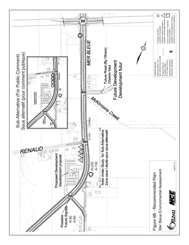
- Intersections are planned at the future development collector roads at a Tee intersection at Renaud Road;
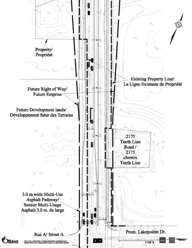
- South of Renaud Road, the alignment swings to the west in a new corridor. In this section, five homes are required as well as some property from the place of worship;
- Old Mer Bleue Road (running through Notre-Dame-des-Champs) will Tee into the new alignment. A sidewalk is recommended to be constructed on old Mer Bleue Road and the roadway will be reclassified as a collector, such that no truck traffic will pass through the adjacent community;
- On its new alignment, Mer Bleue Road will continue south, avoiding the wetland recharge area, much of the vegetated area and intersect with Navan Road at a new Tee intersection.
CONSULTATION
The Mer Bleue Road EA Study was carried out in accordance with the Municipal Engineer’s Association Class EA Process for Municipal Road Projects (2000) as a Schedule C project. During the course of the study, regular update meetings were held with the ACG and PCG to seek input, direction and concurrence on the study findings and recommendations.
The following is a list of public consultation activities for this study:
- Public Open House #1 - February 15/21, 2006;
- Public Open House #2 - April 5, 2006;
- Public Open House #3 - May 23, 2006;
- ACG Meetings - four held throughout the course of the study;
- PCG Meetings - two held throughout the course of the study;
- Transportation Committee - July 5, 2006.
In addition to these events, web pages for both studies were developed and hosted on the City of Ottawa's site, within the Public Consultation link.
The public consultation efforts for this study were successful. The various committees, public associations members of various agencies and public groups/individuals were kept informed of the ongoing activities of this study as well as the outcome through the events listed above. At the conclusion of the study, the majority of comments received from members of the public were of a positive nature.
SECTION B – TENTH LINE ROAD ENVIRONMENTAL ASSESSMENT
DISCUSSION
Current and future land development in the East Urban Community is the key driver behind the need for Tenth Line Road improvements. The ongoing development of residential units in the Avalon Subdivision (Neighbourhood 4); the planned development of the Bilberry Creek Industrial Park and Neighbourhood 5 (Mer Bleue CDP) all contribute to a much higher demand in transit, automobile, bicycle and pedestrian travel. In general, population in the land immediately adjacent to Tenth Line Road is projected to grow from a current population level of approximately 6,000 (2005) to 25,000 in 2021; with employment levels growing from 1,200 (2005) to over 7,000. At this time revised planning applications (CDP, Subdivision Agreements, etc.) for these lands are rising to the municipal application process. These applications are expected to re-align development lands to current markets and demands with overall growth in population being greater than that identified in the 2001 Official Plan, and employment levels somewhat lower than originally forecast. These possible variances were addressed through sensitivity analysis undertaken in the EA needs analysis.
Tenth Line Road will be constructed in stages. Initially, the section from Innes Road to Lakepointe Drive will be built primarily to accommodate the additional traffic demands generated by the Avalon Subdivision. This will be followed over the coming five years with one or more additional road construction contracts resulting in road improvement between Innes Road and the edge of the Urban Boundary. These first phase of works and subsequent phases of construction, have been included in the City’s Development Charge By-law and Long Range Financial Plan.
Study Area Features
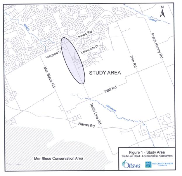
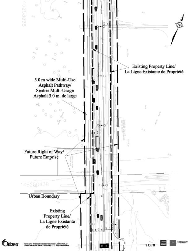
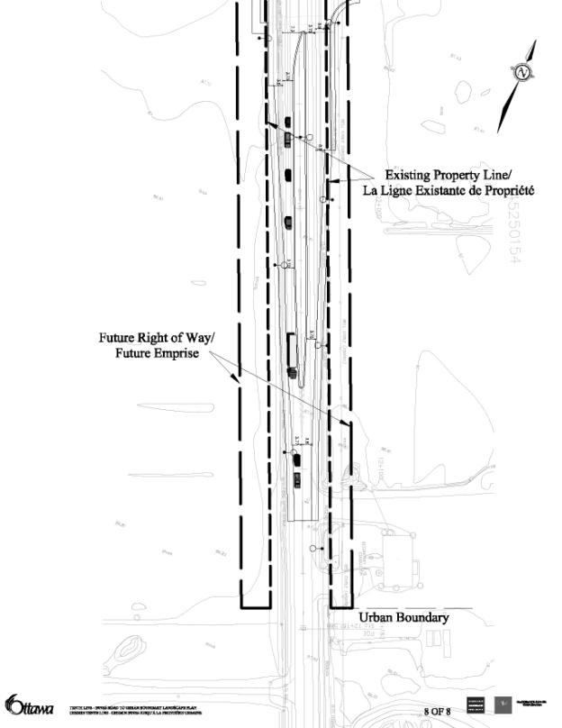
Tenth Line Road is a north-south arterial serving the Orleans Community. The study area for this EA begins at Innes Road, extending southerly approximately 1.8 km to the Urban Boundary limit. Document 5 illustrates the study area.
Tenth Line Road is a two-lane rural roadway constructed on a flat plateau of clay soils which is well drained by an historic ditch and drainage system. The study area contributes run off into the McKinnon’s Creek (South Nation Conservation Authority) and Bilberry Creek Industrial Park trunk storm sewer (Rideau Valley Conservation Authority) watersheds. There are no virgin natural environments, limited tree stock (poplar) in the study area and no significant tree stock within the proposed right-of-way. There were no animal or vegetative population of significance, and no Provincial or Regional populations at risk within the study area.
Alternative Planning Solutions
Consistent with the EA process, developing alternatives for Tenth Line Road considered a broad range of options from ‘do nothing’, to continued use of rural road cross-sections (with shoulders and ditches) through to alternative urban road designs (with catch basins and storm sewers).
Adhering to transit ridership and auto-trip reductions provided in the Official Plan, alternatives were developed using Council approved assumptions such as an overall 30 per cent transit modal split, policy targets for Travel Demand Management (TDM), Transportation System Management (TSM) as well as a percentage of short and mid-distance trips being assigned to travel on bicycle or pedestrian modes.
While the study considered options for re-aligning the roadway (horizontally and vertically), these were rejected early in the alternative development process as there was no basis for altering the road from its current straight horizontal alignment and no short or mid term basis for raising or lowering the roadway. The remaining issues to be addressed through the ‘alternatives generation’ process were the identification of various elements to be provided within the roadway. These were brought into a larger discussion with the public by drawing various roadway cross-sections which showed how the various elements would be provided within the road right-of-way (e.g.: the road cross-section).
Analysis and Evaluation Process
A broad range of alternatives were reviewed prior to undertaking a detailed evaluation process. In general, those alternatives which did not meet the minimum requirements (four lanes, with pedestrian facilities and bicycle lanes) were screened out.
Subsequently, those alternatives that met the minimum requirements were subjected to an analysis and evaluation process used to arrive at a preferred alternative, that being an urban cross section with bicycle lanes and sidewalks. The preferred alternative is illustrated in Document 6.
This alternative was developed through consultation with the ACG and PCG. Subsequently, during consultation with the general public at the open house, the preferred alternative was recommended for the roadway and comments were solicited on this option versus others considered. No negative comments were received to this recommendation. The general response of the public was one of confirmation, and inquiries as to when the road construction would begin.
Refinements
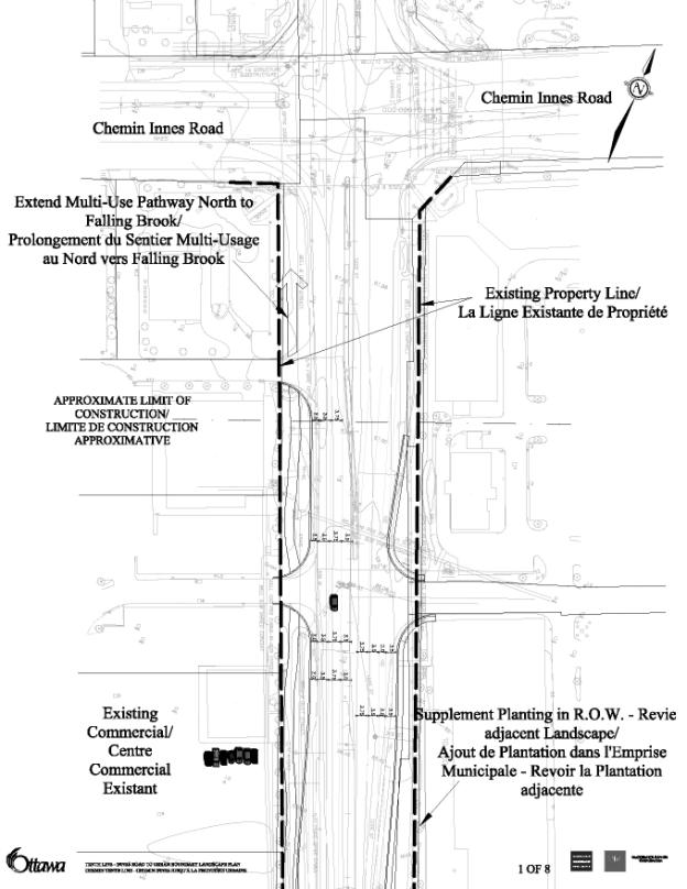
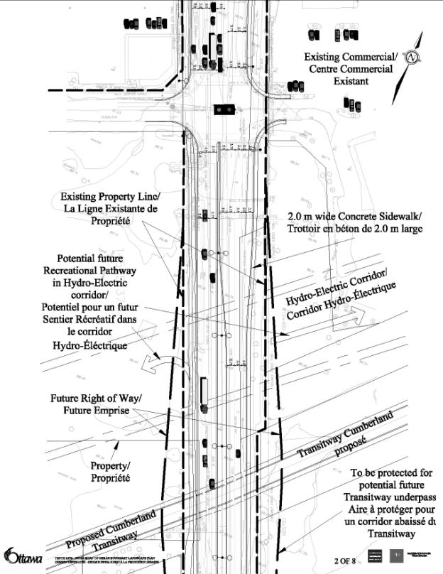
A final design for the roadway was developed from the preferred cross-section selected by the PCG, ACG and open house attendees. It was then refined to address anticipated environmental impacts and prepared for a final round of input the PCG and ACG. The final cross-section, very similar to the preferred plan, was refined to include a multi-user pathway (west side), a concrete sidewalk (east side) and some ditching of storm water at the southerly end of the roadway as it approaches the end of the urban area.
Recommended Plan
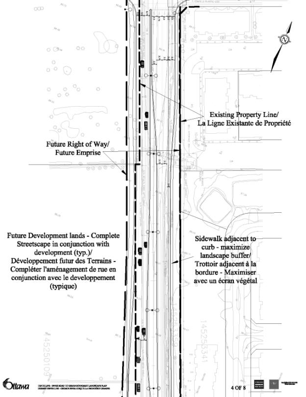
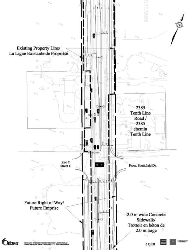
The refinements are shown in Document 6. The plan includes:
- Provision of adequate lands to permit eventual construction of the road plan developed through the EA process;
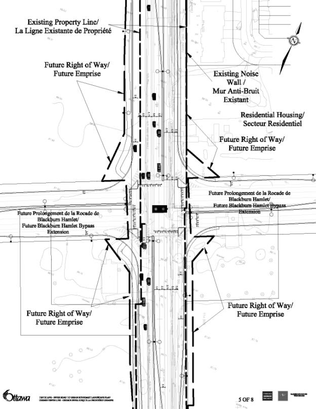
- Provision of adequate lands to accommodate the eventual grade separation of the Cumberland Transitway/LRT at Tenth Line Road as provided in current Council policy;
- Double left-turn lanes and traffic islands were included in the intersection design of Tenth Line Road and Blackburn Hamlet By-pass Extension based on a detailed review of traffic demand and confirmation with City staff. This review addressed the length of pedestrian crossing as excessive when traffic islands were not provided. The study noted that pedestrian crossing times, without islands, would degrade intersection traffic level‑of-service (LOS) to below City standards. Similarly double left turn lanes (for every approach) were required to process traffic levels at 2021 assuming 30 per cent assignment of peak hour travel to non-auto modes;
- Landscaping was also identified on the refined plan in order to provide greater aesthetic beauty and variety to the streetscape.
CONSULTATION
The Tenth Line Road EA Study was carried out in accordance with the Municipal Engineer Association Class EA Process for Municipal Road Projects (2000) as a Schedule C project. During the course of the study, regular update meetings were held with the ACG and PCG to seek input, direction and concurrence on the study findings and recommendations.
The following is a list of public consultation activities for this study:
Public Open House #1 - February 15/21, 2006;
Public Open House #2 - April 11, 2006;
Public Open House #3 - May 30, 2006;
ACG Meetings – three held throughout the course of the study;
PCG Meetings – three held throughout the course of the study;
Transportation Committee - August 16, 2006.
In addition to these events, web pages for both studies were developed and hosted on the City of Ottawa's site, within the Public Consultation link.
Consultation efforts through EA process has met or exceeded the requirements of the EA legislation and guidelines and that issues raised by the public have been addressed within the study process.
FINANCIAL IMPLICATIONS
The funding for the Environmental Assessments for Mer Bleue and Tenth Line Road was approved in the 2005 Capital Budget in Accounts 903211 and 902319 respectively.
SUPPORTING DOCUMENTATION
Document 1 Mer Bleue Road EA Study Area
Document 2 Recommended Plan for Mer Bleue Road
Document 3 Mer Bleue Road EA Analysis and Evaluation Details
Document 4 Mer Bleue Road EA Public Consultation Details
Document 5 Tenth Line Road EA Study Area
Document 6 Recommended Plan for the Tenth Line Road EA
Document 7 Tenth Line Road EA Analysis and Evaluation Details
Document 8 Tenth Line Road EA Public Consultation Details
DISPOSITION
DISPOSITION- FOR SECTIONS A AND B
Planning and Growth Management Department to prepare the Environmental Study Report for Mer Bleue Road and initiate the 30-day public review period.
Planning and Growth Management Department to prepare the Environmental Study Report for Tenth Line Road and initiate the 30-day public review period.
Corporate Services Department, Real Property Asset Management (RPAM) Branch to begin acquiring necessary property needed for the construction of the first phase of the Mer Bleue Road reconstruction.
Corporate Services Department, RPAM to begin acquiring necessary property needed for the construction of the first phase of the Tenth Line Road reconstruction.
MER BLEUE ROAD - RECOMMENDED
PLAN AND
MER BLEUE
ROAD EA ANALYSIS AND EVALUATION DETAILS DOCUMENT
3
Mer
Bleue Road EA Public Consultation Details DOCUMENT 4
Recommended
Plan for the Tenth Line Road EA DOCUMENT 6
Tenth Line Road EA Analysis and
Evaluation Details DOCUMENT
7
The Tenth Line Road EA project was
studied as a single section of roadway for evaluation purposes. As the existing road alignment is relatively
flat and straight with only two remnant occupied dwelling units and no other
natural areas or built structures within the road right-of-way, no partitioning
or subdivision of the overall study area was considered necessary.
Alternatives for the project initially considered the widest possible range of options including: ‘do nothing’, alternate vertical and horizontal road alignments, and alternate cross-section elements to be considered within the road cross-section.
Following a detailed review of existing conditions, it was confirmed that there was not justification to vary the road from its current alignment. In addition there were geotechnical reasons to restrict changes to the vertical alignment of the existing roadway. This, combined with a plan to install a trunk sanitary sewer down the easterly edge of a widened Tenth Line Road right-of-way, meant that alternatives were restricted to variations in the road cross‑sectional elements (number of lanes, pedestrian facilities, cycling facilities, etc.). Decisions to screen out variations in vertical and horizontal alignment were evaluated and confirmed by the PCG and ACG.
Following the screening of alternatives, the seven cross-sectional alternatives reviewed in detail included:
- Do Nothing : two-lane, shoulders, ditches
- Alternative 1 : four-lane undivided, curbs, shared bike lane, sidewalks
- Alternative 2 : four-lane divided, curbs, shared bike lane, sidewalks
- Alternative 3 : four-lane divided, shoulders and ditches, exclusive bike lanes, sidewalks
- Alternative 4 : four-lane undivided, exclusive bike lane, curbs, sidewalks
- Alternative 5 : four-lane divided, exclusive bike lane, curb, sidewalks
- Alternative 6 : four-lane undivided, exclusive bike lanes, shoulders, ditches, sidewalks
A comprehensive evaluation methodology was developed for use by the PCG and ACG. Based on their input a single preferred cross-section alternative, Alternative 5, was selected. Through a second public open house, the public was asked to comment on the evaluation methodology and findings. No negative comments were received on the preferred cross-section.
Based on the evaluation and consultation process , Alternative 5 (a four-lane divided roadway with exclusive bicycle lanes, curbs and sidewalks) was selected as the preferred design for the roadway.
Agency Consultation Group (ACG)
The ACG was composed of representatives from the City of Ottawa Planning and Growth Management, Public Works and Services and Real Property Assessment Management. In addition, external agencies such as the Rideau Valley Conservation Authority, South Nation Conservation Authority, Ontario Ministry of the Environment, area developer (Taggart Realty and Minto) and consultant staff contributed to the study through this group. The ACG’s role in this study was to vet all technical information presented and ensure the outcome avoided or properly mitigated any natural, social or physical features of the study area. The group met six times throughout the course of this study and all members endorsed the final recommendations of the EA.
Public Consultation Group (PCG)
The PCG was comprised of various public and private corporate parties (developers, property owner’s representatives, land owners, etc.) as well as special interest groups (municipal advisory groups, etc.) who expressed an interest in participating in a more formal consultation process than the open house format. The PCG met on three separate occasions during the study process and contributed to the identification of broad policy issues as well as property-specific issues.
Public Open Houses
A total of three open house sessions were held over the course of the study to provide an opportunity for the general public to participate and share insights into the planned study process; the preliminary findings and alternatives generation and finally to review and provide comment on the proposed preferred widening plan.
Open houses were held on February 15 and 18 (first open house was offered on two occasions on Tenth Line Road (Ray Friel Centre) and at the Notre-Dame-des-Champs Community Centre) ; April 11 and May 30 respectively. Advertising for the open houses was published in the major city newspapers as well as community newspapers serving the study area. In addition flyers were distributed to addresses within the study area for the first open house, and to all registered open house participants for the second and third meetings. Attendance at the events were 98, 12 and 21 respectively. Members of the public were asked to submit their comments in writing through the provision of Comment Sheets at each of the public meetings.
Study Issues
The majority of issues raised through the study were identified through the technical studies which were associated with the EA. These were addressed above in the DISCUSSION section of this report.
To clarify those items summarized through the DISCUSSION section, the following section is provided as additional detail on issues which were addressed through the consultation process offered through the ACG, PCG and three open houses:
Fish Habitat
Anticipated downstream impacts from the Tenth Line Road widening (preferred Alternative 5) are limited to those already considered the Master Drainage Plan for the Bilberry Creek Industrial Park (BCIP) trunk storm sewer within the Rideau Valley Conservation Authority (RVCA) and the McKinnon’s Creek catchment area within the South Nation Conservation Authority. Recent approval of the East Urban CDP Phase 1 included various stormwater management (SWM) facilities aimed at limiting the quantity of run-off into the various catchment areas while also meeting quality requirements. Through the EA it was determined that both quality and quantity targets established in the Master Drainage Plan could be achieved through on-road and off-site SWM facilities as provided in the CDP.
Urban Natural Areas
The study area was reviewed to identify sensitive natural environments and species at risk. In general, the study area is comprised of lands which are devoid of original natural environment, as all lands have been used for agricultural purposes. No species at risk were identified as being native to the study area.
Property Impacts
As part of the EA evaluation, additional lands required for road construction were identified. In general, right-of-way widenings are consistent with those provided in the Official Plan which calls for a widening to 37.5 metres on the existing centre-line for there is a provision for an additional five metres of land to the West of the centreline over the most southerly lot to accommodate a transition to a ditch network as provided in the exiting rural road design.
In some cases additional lands beyond the OP specified 37.5 metre right-of-way, are required including:
- Additional Property is required in proximity to the future alignment of the Cumberland Transitway / LRT to allow for future grade separation.
- Additional property is required in proximity to the Tenth Line Road / future Blackburn Hamlet By-pass Extension to accommodate deceleration and acceleration lanes, turn lanes and traffic islands.
Property-Specific Issues
Beyond the general issues identified above, a number of specific issues were identified during the study process. These have been carefully considered in the development of refinements to the preferred plan.
· The feasibility of having an all-directional access on to the widened Tenth Line Road from property on the south-west corner of the Tenth Line Road / Future Blackburn Hamlet By-pass Extension was raised by Dan Paquette (Dan Paquette Associates on behalf of Petro Canada).
· Concern that any road reconstruction would include replacement of existing driveway culverts to reduce potential for Spring flooding, etc.
· Right-of-way widenings impact on a variety of properties within the study area [Petro Canada land (per above); Minto lands; private houses (two)].
· The veracity of existing property lines shown on existing conditions documents, in particular property lines for Tenth Line Road right-of-way widths south of the Urban Boundary, beyond the limit of construction, on property owned by Mr. Marcel Bisson (Lot 4, Concession 11). Mr. Bisson contested that a right-of-way widening approved by Cumberland Township Council was never formally acquired or paid for and that the right-of-way should be shown as remaining at the original measure of approximately 66 feet (20 metres). Because Mr. Bisson’s lands are beyond the extent of the project, it is also outside the mandate of the EA to address this issue.
· The timelines for the City to purchase right-of-way widenings, in particular for the two remaining home-owners, was identified as a concern through the study process.
· Access to existing driveways at 2385 Tenth Line Road was identified as a concern.
· Traffic islands, as a proposed design element, were objected to due to impact on pedestrians.
· Concern that the studies conducted for the EA were incomplete and that members of the public did not receive sufficient responses to questions asked.
· Concern that a complete road (network) study is required for lands south of Blackburn Hamlet By-pass Extension (North of Regional Road 28) for Mer Bleue Road, Tenth Line Road and Milton Road to assess the requirement for the future before road is included in Official Plan.
· Concern that no land base has been identified (for development) between the proposed Blackburn Hamlet By-pass and the CPR Rail Tracks (South of Navan Road) to justify a north-south four-lane arterial.
· Concern that existing road pavements marking (near Vanguard Drive/Innes Road Commercial properties) are incorrect.
Each of these issues has been carefully dealt with, where feasible, through the study process and the specific manner in which the issues have been received and addressed is documented in the open house Summary Reports.